Sunday, August 29, 2010

Day 8 : Kirkjubaejarklaustur to Skaftafell National Park and Jokursarlon

Probably the easiest day so far on this journey around Iceland. After a late night of clothes washing, photo editing and blog writing we started the morning at a leisurely pace.


The first stop was the Museum at Kirkjubaejarklaustur. A modest place with the obligatory pull up banners and sign boards explaining more volcanic activity in the region. The main attraction we wanted to see was a movie that documented the 1784 eruption that killed 1/5 of Icelands population. 12 cubic kilometres of lava spilled from 2 giant fissures (up to 27km long) over a period of 7 months, destroying the land at first then poisoning the air and ground. 1000’s starved and much of the livestock for eastern Iceland was lost. The clouds of poisonous gas that blocked the sun across Europe was said to have caused more than a million deaths related to starvation in lost crops. If it happened today, flights in the northern hemisphere would be cancelled for up to 18 months and untold lives lost. On average this Volcano wakes every 200 - 500 years, so it could happen in our lifetime.


After seeing this dramatized horror story of local geology it was onto to see the Vatnajokull and Jokulsarlon. It was the first warm sunny day since we arrived and we wanted to make the most of these spectacular locations. The drive to Jokulsarlon took us past the the mountain range that was home to the Vatna Glacier, and Icelands highest peak at 2000m. Permanently blanked in ice and snow, it is also the home of several volcanos. In 1996 a large eruption under the glacier caused melt water to accumulate in a large mountainous lake. The ice finally lifted after 30 days of melting and the water cascaded down the side of the range. It flowed at a rate of 50,000 sqm per second for 48 hrs destroying roads and bridges as the water carried down 3 story building sized blocks of ice and water. The movie we viewed at the visitor centre was just stunning.


At the eastern side of the Glacier is Jokulsarlon. A glacial lagoon that at the bottom of a glacier (as many of the glacial tongues around here have), causing car sized icebergs to clave off in a postcard perfect setting. One of my ‘must see’ destinations it did not disappoint. Eerily silent except for the sound of dripping water as the large bergs melted in the sun. Simply wonderful, that the pictures below can only begin to portray.


We then travelled back to the Skaftafell National Park to set up camp for the afternoon. For the first time in our trip we had time for some rest and an afternoon nanna nap. Waking at 5.30pm we decided to hike the surround hills and check out the local waterfalls. It was a 5.3km hike with beautiful vistas of the flood plains and lava fields below. After some ‘jesus fish’ (postcard) photos of the hero waterfalls and surrounding streams we made out way down to the plain. It was on the descent that we came across ‘Sell’. A 100 year old farm compete with the traditional grass covered roofs that we saw in so many postcards. Under the care of the National Museum it is perfectly restored and gives us a glimpse of how the traditional icelandic villages were like. The roof is made from beams of timber, usually driftwood, covered in slate like rock, then dirt and finally grass covering the entire structure. The buildings are semi buried into the hillside to add more protection from the elements and provide more warmth. A picture perfect setting that wasn’t outlined with the attention it deserved in our guidebook.


A little further downhill, we found a small path into a small forest. There was a lovely pool in a dell, where they would keep the lambs overnight so the ewes could be milked each morning. The forest, such as it was, was pretty - a huge poplar, spruce trees towering above, and birch trees - both silver birch and a smaller, twisted type of birch. There don’t seem to be any extensive forests here, but there are pockets, and tall trees do exist - we are seeing more farms here in the south of the country with rows of trees as wind breaks for their farms.


Curry and Rice for dinner, washed down with Icelandic Vodka and 2 episodes on True Blood ended our day, ready to sleep in our van with a view of the enormous glacier and 5 of its flows.


Saturday, August 28, 2010

Day 7 - Middle of nowhere, on the way to Kirkjubaejarklaustur (I spelled it without looking - I’m getting good at this Icelandic ;)

By 5.00am it was light enough to head off - both of us still feeling very tense and nervous. Nyldalur would have a warden / ranger but would have no fuel. It was 50km away, and petrol from Hrauneyjar was still another 100km after that. We were not going to make it. We tried to be optimistic - when we ran out, someone would come by, and we should be within 30 - 50km of the town by then. We would get help. We decamped quickly, and were on the road at 5.20am. The cloud had lifted, so we were now able to see much further, and the light was brighter. There was very little rain - only patchy, so the stress of the changing wiper speed was removed. 2 hours of lava field, multiple river crossings - including one where Charlie had to test the depth of the glacial melt water to determine if we could cross safely. Off came the shoes, socks, and 2 outer layers of pants. Up rolled the thermal pants, and out he went - I do have photographic evidence. He quickly decided it was ok to pass, and spent a few minutes trying to warm up in the car before we put the car back into low to chug through the torrent. Finally, we rounded a bend and saw Nyldalur! Only 2 more river crossings. We got in there, jubilant and ready to beg for fuel - although they don’t sell it, they must have some, and getting it from the ranger station is surely better than needing to be rescued 40 km down the road. We went into the information hut - there is accommodation here, and germans were preparing their breakfast. No one had seen the ranger - he must be still sleeping. So we had some breakfast ourselves (creamed rice and apricot halves), wandered around, and waited. And waited. And waited. By 9 o’clock, I was getting pretty toe-y. After knocking on the door of the wardens hut on and off for 2 hrs, sitting in the cold, eventually a man asked if he could help us. Hallelujah! He poured a 20L can of diesel into our tank, we handed over our $40 (same price as in the towns here and cheaper than it was in Hrauneyjar) and we were on our way. More lava. More rivers. But this time, no wipers, and a bit of a view, and secure in the knowledge we would get to the next town. This last 100km took only 2.5 hrs - much easier going over all, and when we filled up in Hrauneyjar, we had only 10.5 L to spare - if the warden had given us only 10L as we had asked for, we would have limped in on fumes.


Into the cafe - the fuel cost $105 to fill up, and then we splashed out on lunch. $53 for 2 burgers, 2 cokes and one beer. Oh well, it is what it is. And of course, this cafe / servo had free wifi. Why not? So Charlie was able to upload a couple of these blog postings while I planned the rest of our afternoon.


Next stop - Landmannalaugar. This is a favourite destination for local and foreign travelers - ‘painted’ hills of yellow and red rhyolite, steaming vents, lava fields, lakes. As we got closer to the Landmannalaugar region the landscape started to change dramatically from the barren monochromatic land we had seen 2 days previous. Large hills rose from the desert floor. At first they were made of black sand covered in a spiders web of lichen. As we got nearer the colours changed from black to to rust red and ochre sand. All the geological colours you could imagine with a blanketing of bright green lichen as far as the eye could see. Our photos couldn’t capture the enormity or beauty of the region so we just soaked it in. We stopped at Ljotipollur - a red crater filled with blue water - rich in trout (!). The black and red (from iron ore deposits) steep crater had stripes of green lichen, streaking down the slope. Were scambled down the to waters edge - following what started off looking like a track, but was really a water course with some other boot prints. We kept pulling off the road to take ore pictures to try to capture the colours, but even with the sun poking through the clouds, it couldn’t keep up with the beauty. One hill we stopped on was very soft soil and lichen - I noticed some cracks and peered closer - the entire soft hillside was full (or hollow?) of fissures, and most of the ground we stood on was only inches thick! There were holes I could not see the bottom of, and other fissures that were twice my height in depth. We stepped very very carefully!


At the Landmannalaugar hut, we walked across a lava field - this one had mainly obsidian rocks - shiny black glass like rocks formed when the lava cools very very quickly. With the soft green moss and lichen growing over it, it was a very pretty (and crowded) walk. Over the lava field, we came out into a flat valley, with these painted hills around it - steaming vents dotted these hills, but without the noise and ferocity of Hverir a few days ago. One green mossy hill was completely steaming - we walked up it along the path, feeling the rocks that were perhaps room temperature rather than hot or cold. It would look amazing in winter in the snow - this hill would be green all year round thanks to the central heating :) We spent 5 hours wandering around this region, then headed towards the coast. More stunning vistas, many more river crossings, eventually reaching - wait for it - sealed road!!!!! We headed for the small town of Kirkjubaejarklaustur - again, all farms have their own waterfall from the cliff behind - all postcard perfect. A massive rainbow appeared to touch the road in front of us as we turned off and made camp for the night after another 14 hour day of traveling. $3.50 for a shower, $30 for the nights campsite (hand washing the clothes, then trying to dry them overnight) and we’ll be all ready for tomorrow!


Testing the depth of the glacier melt water. So cold - so painful.


Day 6 : Ice Caves, Glaciers, Volcanoes and The Road to Hell and Beyond and then some.

The biggest day of driving on this holiday awaited us. We were about to cross the interior From Lake Myvatn down to Nyldalur and through to Landmannalaugar. At over 500km of driving it was going to be quite a day. In Australian terms this isn't much to write home abut. But as we knew the road was rated as ‘white mountain roads’ we were in for a long haul. Our last ‘white’ road was to the Lava Caves at Surtshellir on our first driving day. The 10km road was unforgiving in our camper and when it turned into 25km it almost turned into tears. Add to this, Myvatn was our last chance for fuel for over 450km - Agust our friendly car hire man told us that the Triton should do 400km+ easily. We were playing with fire but wanted to push on.


Our first destination was the Ice Caves at Kverkfjoll. It was a southern detour down to a northern outcrop of the enormous Vatnajokull Glacier of about 125km out of our way but loosely factored in. The road was tough, very tough. Rocky, winding across lava fields, deep black sand and driving, unrelenting rain. According to our guide book the rain was ‘mist driven horizontal by the driving wind’. Either way, it became quite the ordeal with our squeaky out of date windscreen wipers and a road that took us in all directions. The wind and rain came consistently, but our position kept changing, so as well as trying to negotiate a path through the rock, keep a lookout for the road markers so we knew where the ‘road’ was meant to be, shift gears between 1, 2, and 3 and keep adjusting the wipers from each grade of intermittent to consistent - it was stressful. After taking a wrong turn and adding 25 extra km to our journey we made our way to the Ice Caves. It was a box I wanted to tick on our trip. From the photos I’d researched it looked absolutely stunning. The caves are formed by heated water running from under the glacier. The running water turns into a raging river as it exits the glacier. I’d expected caves you could actually explore - but Im guessing we were 4 months too late. It was still a sight to see though. The Vatnakojull Glacier is the world’s largest icecap outside of the poles, covers 10% of Iceland and contains 3000 billion tonnes of ice a-top the mountainous moon like landscape. A hike down to the base of the glacier saw some good pics and then it was back to the car.


Out next stop was Askja Volcano 100km due northwest. Again the driving was tough averaging between 45 - 60kph. We were still in good spirits though and were looking forward to seeing this landmark. Askja caldera is 50 sq km - in 1875, 2 cu km of tephra (volcanic sand and rock) were ejected from the Askja volcano, bits of it landing in continental Europe. Ash from the eruption poisoned much of the cattle here and sparked a wave of emigration to America. After the initial eruption, a magma chamber collapsed creating an 11 sqkm hole 300m below the rim of the original explosion crater. This filled with water, and is now icelands deepest lake at 217m! Askja has erupted as recently in 1961, and is due to go again about now. Along with a few other big ones - it is amazing to realise most of this landscape is so young, and will change again many times in our lifetimes - this years eruption at Eyjafjallajokull was very minor by Icelandic standards and we will see many bigger ones this decade.


As we arrived at Askja it became apparent that it had snowed in only the last day or two. Light now blanketed the black sand and jagged mountain range that formed the volcano. It was stunning - looking like zebra stripes across the land. I was probably excited more for the reason of never experiencing real snow before. We arrived at the car park at 4.00pm, 4 hours past the time we had budgeted for the journey. Un-fazed we dressed in our layers of gloves (including black industrial dish gloves all round!), balaclava, jackets and multiple underlayers and headed onto the frozen wasteland to see the blue lake at the base of the caldera - 4.6km hike across the range. The going was flat, easy and fun. We threw snow balls, trudged in 15inch deep snow (when we found it that deep!) and pondered about the forces that created this landscape. Coming back was hard. As we had entered with a tail wind we then had to deal with it on our faces on our return. The rain was constant and our wet weather gear drenched. The washing up gloves held true so that was a bonus.


It was at this point that that our goal became more real. We had to make 235km across the barren landscape with under a half tank of fuel, wind, 2ÂșC outside temperature and the ever present rain.


As we left Askja the terrain turned from bad and into a nightmare. We had already driven for 8hrs and only seen 3 cars, so a sense of real danger started to become apparent. On reflection, in local terms, this would be the equivalent of doing the Gunbarrel highway with a Lonely Planet guide and a ‘she’ll be right’ from the Hertz Rental lady. We had no idea of how tough it was going to be. Tory asked about the road from a local, I asked about the river crossings and no-one was fazed or concerned - this was a good road, a trusted track and it seems, a cake walk for anyone with a 4wd. How wrong. How wrong.


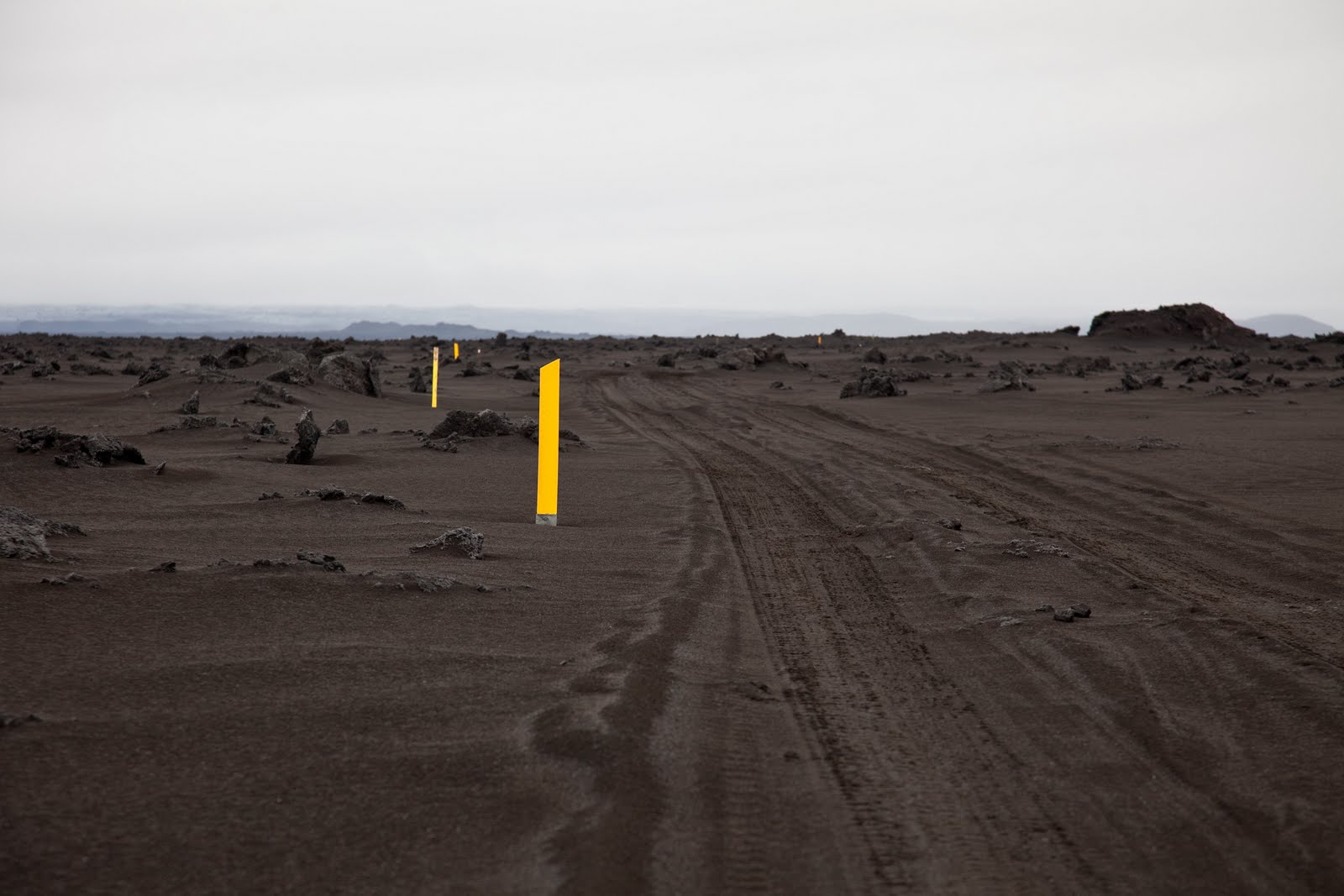
The first 20km consisted of massive floodplains that stretched into the horizon. The road turned into a river that we followed, like a salmon heading upstream. The next section was 10km of foot deep black sand. It was rugged and pulled at the steering wheel whilst the ‘mist’ bore down on us. Each section of terrain change I had to re-adjust my calculations for our destination. ‘40kph, 190km to go - 4.5hrs’, 25kph, 165km to go - 6.6hrs’ and so on. As we exited the sand we entered the Lava Field. At 2200 sqkm it was vast and all you could see for hours upon hours. At some points we were going 20 in an hour and less. Wherever I could, I put the clutch in and rolled down hills, kept an eye on the taco and adjusted gears to suit. The fuel gauge was my god and I worshipped it’s existence in between gear changes and wiper speeds.


3hrs in, in my shoulders started to ache from the violent battering. The wheel flew this way and that, as the tires hit jutting stones and brittle lava from either a few generations or an eon ago. The landscape was pure monochrome - black, grey and the white sky, obscuring our view beyond 40m or so and my desire to capture it digitally was taken over with a feeling of survival and a need for safety. Outside the temperature with wind gusts and rain was in the minuses. The light was fading at the same speed as our fuel gauge. A camp named Nyldalur was 90km away and after 2 hrs driving we were still only 35km closer. We decided to pull off the ‘road’ and camp the night. We popped the camper roof dressed in balaclavas, woollen hoods and our ever present gloves, and climbed inside. Dinner was a cup of soup and minimal conversation. We lay our heads down after 13hrs driving and only 390km of travel, taking off only the wet weather gear to try to sleep on the windy, barren ridge.


Our campsite for the night.


Rugged up ready for the snow covered volcano. Fricknn cold - incase you wondered.


Driving the road from hell.